
|
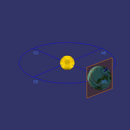
This scheme shows Furaha rotating around its axis and around its sun Jua. The square through the planet shows which half is lit by the sun and which side is not, or where it is day and where it is night. The axis of the planet is tilted, and points toward the same direction regardless of where the planet is in its orbit. When the North pole is tilted most directly towards the sun, we speak of the Summer Solstice, marked 'SS'. For the Northern hemisphere this is the longest day in the year, and the shortest night. Half a year later Furaha reached the point marked 'WS', for 'Winter Solstice'. The North pole is now tilted furthest away from the sun, and on the Northern hemisphere this is the shortest day in the year -with the longest night-. In between there are two points in the orbit where day and night are equally long. The Spring Equinox (SE) denotes the beginning of spring, and the Autumn Equinox (AE) the beginning of autumn. The tilt has been greatly exaggerated for clarity: it is shown at 33 instead of 18.3 degrees). In the animation Furaha only revolves around its axis a few times instead of 551.1 times. Mind you, all this is simple because Furaha's orbit is nearly circular, just like earth's; if it would be very elliptic, the seasons could have different lengths, and summer in the North might last longer than in the South, and... oh well, never mind. |
|
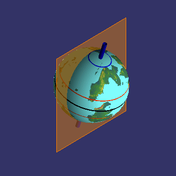
Here is just one day as a close up of the Summer Solstice for the Northern hemisphere. The axis sticks out at the North Pole, and the area immediately around it remains in the light for an entire rotation: there is no night. But for a point a bit south there will be a short period of darkness during a rotation, and the duration of darkness increases until you arrive at the equator, where light and day each last for half a rotation. Here, the tilt is shown correctly at 18.3 degrees. The polar areas would be larger if the tilt were larger, as is the case for Terra's axial tilt of 23.5 degrees. |
|
|
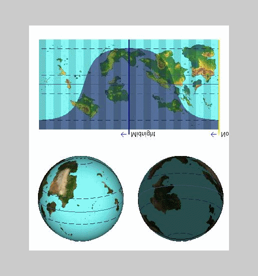
The combination of tilting, the orbit and rotating around the axis means that the areas of light and dark create complex patterns on the planet's surface over time. On a sphere they are more intuitive than on a flat map: on a sphere the line dividing dark and light areas is always a circle, but on a flat map a circle can become something more complex. For the Northern Summer Solstice the correct shape is shown here. Again, the area around the North pole is always in the light, and the South pole is always in the dark. Over one axial rotation the shape travels around the globe as shown here. The vertical stripes show 24 time zones. These Furahan 'hours' last longer than a Terran hour! The horizontal lines show the edges of the polar zones, 18.3 degrees away from the poles, as well as those of the tropics, 18.3 degrees away from the equator. The two globes below show the day and night sides of the globe. The day side is shown as if seen from the sun. The North Pole is tilted towards the sun. |
|
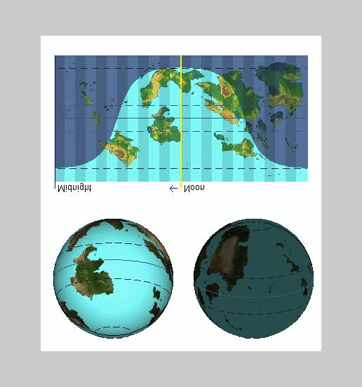
The shape of line between light and dark changes in the course of a year. During the Winter Solstice the shape is flipped upside down, so then the South pole receives its share of light. And at the equinoxes the terminator runs through both poles. Suppose we make a map for noon for each day of the year. The result is shown here: the shape no longer travels towards the west because we show only noon, but instead you see it change shape. The two globes illustrate this apparent wobble. The first one shows the view from the sun. In reality the axis does not wobble, but it seems to do so because of where we are, on the sun. (Mind you,I still have no idea why the lettering is upside down.) |
|